Thursday, 12 September 2019

Geoffrey de Marisco - The Man that built Nenagh Castle?


EDIT: I wrote this post based on secondary sources that had taken information by Hervey Morres as being accurate.

In the post I wondered was this effigy (pictured) - Geoffrey De Marsico as outlined in Morres's book (see pg 334 of the Google book version).
However the table tomb that the sketch shows no longer exists (and likely never did).

Manning in his piece in History Ireland states "A print of the effigy of a knight at Hospital, Co. Limerick, from Morres’s 1828 book. He added the fictitious tomb surrounds with the de Montmorency arms, and further embellished the print by adding an inscription to the base of the tomb surround."
https://www.historyireland.com/hervey-morres-and-the-montmorency-imposture/

Some reputable sources such as Hunt's Irish Medieval Sculpture Figures records the effigy as De Marisco and so does the Trinity website.
http://www.tara.tcd.ie/bitstream/handle/2262/38941/ertk2167.jpg?sequence=1&isAllowed=y

The SMR note on archaeology.ie also notes it as De Marisco.

However I personally would be thinking, based on the fraud / embellishment shown to date in my other posts in relation to sketches in this book, that this needs to be called into question.

https://www.facebook.com/Thetipperaryantiquarian/posts/pfbid02z9w8jAvBnPNECKC18NQprgTTXmQz7vFTyLMRUPXR7HLLegWqMGsMCRbXi4moL7Wpl

To follow the thread on Hervey Morres
https://www.facebook.com/Thetipperaryantiquarian/posts/pfbid024i1Jgv3bh3xwM8HcREVcPAtr8pgyUk8Bs5nh37FCTsz7gmUZGEUpM6rs4KZLY6rJl

So the big takeaway for me is to check your sources and try to go back to the primary source if possible.

It also shows that even supposed sketches of monuments drawn at a certain date aren't 

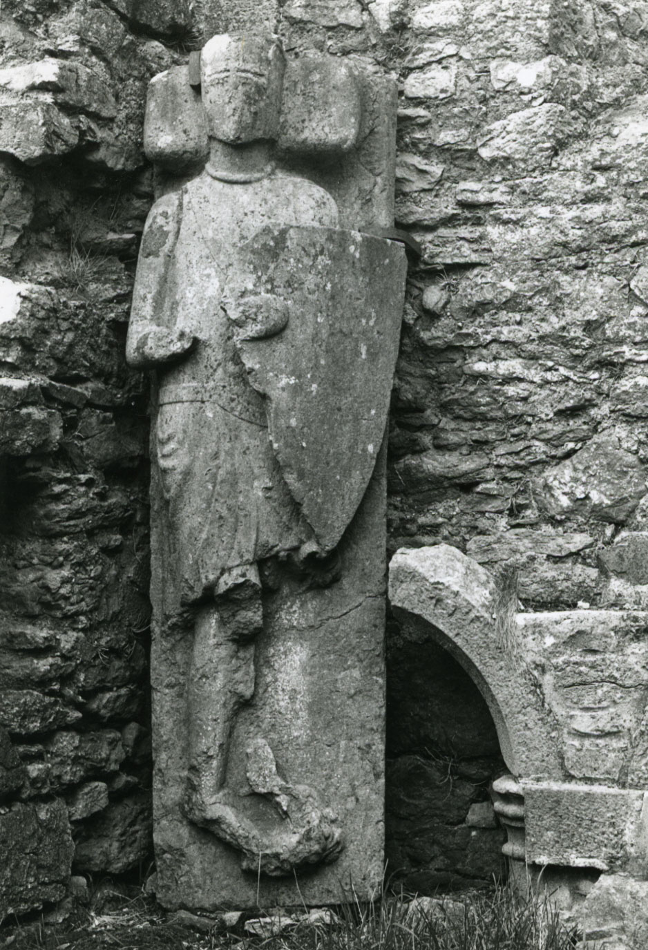
Is this an effigy of the man that built Nenagh Castle 800 years ago?
This effigy of a Knight is located in the Church of the Hospital of Any in Hospital Co. Limerick.
It is believed to be the figure of Geoffrey de Marisco, an Anglo-Norman knight who founded the Hospital in 1215.
Geoffrey seems to have connections to the Tipperary area in that possibly either himself, his father (or maybe a brother) was also known as Jordan de Marisco, who the town of Cloughjordan was called after (he owned a tower-house there).
It may have been his son William (or another Jordan) that married a daughter of the Lord of Latteragh as a William de Marisco is listed at the tower-house of Latteragh in 1254 (He was granted a weekly market here in 1254).
The surname De Marisco later became Morris, Morrissey or Fitzmaurice.
The connections are a bit sketchy as I've read other versions to the source above but it is fair to say that the De Marisco's / Morris family had strong connections with the Tipperary area.
This link here even suggests that he may been responsible for building Nenagh Castle?
https://irelandxo.com/ireland-xo/message-board/history

Update:
A History of Hospital and its Environs by Michael F. O'Sullivan seems to disagree with this idea (pg10), it states
"The Knight in the Corner
The effigy of a knight in armour of the period, in the north eastern corner of the abbey, is probably from the tomb of Roger Outlawe, Grand Prior from 1315 - 1340. Prior Outlawe was the first Grand Prior that we know to have been definitely born in Ireland. His family, one of recognised standing and wealth, had been established in Kilkenny for over 100 years before he was born.
Roger Outlawe was one of the most notable men of his day in Ireland and held many of the highest offices in the state. His services in the field against the forces of Edward Bruce were rewarded by crown grants and leases, and though much of his land was laid waste during the war, he successfull made good the damage."

Update:
The more up to date paper "The archaeology of the Irish Hospitaller preceptories of Mourneabbey and Hospital in context" by Eamonn Cotter featuring in the book Soldiers of Christ seems to confirm that the above effigy is Geoffrey de Marisco.
pg 119
"standing in the south-east corner, is of a knight and lady, dated by Hunt to the second half of the thirteenth century and said by him be 'the earliest double effigal tomb in Ireland, and perhaps earlier than any in England also'. The second effigy is of a single knight, dated by Hunt to 1260 and discussed elsewhere in this volume by Paul Caffrey. Hunt suggests it represents a member of the de Marisco family, one of whom - Geoffrey - founded this preceptory in 1215. A nineteeth - century genealogy of the de Marisco family shows an illustration of the effigy lying on a chest-tomb and specifically identifies it as representing Geoffrey de Marisco. Hunt cites another source, Memoirs of the family of Grace, as showing an illustration of the effigy on a tomb-chest, but concludes that the tomb-chest is 'probably imaginary'. Significantly, a photograph in Trinity College Dublin's online Edwin Rae collection shows the effigy lying in a niche in the north wall, near the north-eastern corner of the church, a common location for a founder's memorial. This may have been its original position and it is likely that it does indeed represent Geoffrey de Marisco, who died in France in 1245."

Caffery in "Visual culture of Hospitaller Knights of the Priory of Ireland" also in the same book above then states on pg 155
"There are the remains of three effigy tombs in the ruins of the church of the preceptory of Any dedicated to St John the Baptist at Hospital, Co. Limerick. The preceptory of Knockainy or Any was founded by Geoffrey de Marisco (d. 1245). in 1200 and the most intact effigy is traditionally associated with him. Plates of the ruins and the effigy were engraved to illustrate Hervey de Montmorency Morres' romantic Genealogical memoir of the family of Montmorency styled de Marisco or Morres (1817) complete with an elaborate tomb decorated with the Morres arms, consisting of a cross between four eagles (fig. 8.5)."


The confusion in O'Sullivans book may be as a result of the following

pg 157
"One of the other tombs may have been sculpted for Roger Outlaw (d. 1341), prior of Kilmainham (1317-41) who died at the hospital at Any and was buried there. There is also a large double effigy tomb depicting a knight and his dame."

So it is likely then that there is an effigy of Geoffry de Marisco and also of Roger Outlaw. 

Wednesday, 24 July 2019

The Fair of Munster at Rathurles, was this the original site of Nenagh?


1840s Map of Rathurles Rath - The Fair of Munster (c) OSI
Rathurles is a huge multi-vallette ring-fort near Nenagh in Co. Tipperary.  It is described in the Archaeological Inventory of County Tipperary (Vol. 1 – North Tipperary) as a;

Ringfort - “Situated in undulating pastureland. A roughly circular area (diam. 55m N-S) defined by an inner bank largely reduced to a scarp, a fosse (Wth 6m), a berm or walkway and an outer fosse (Wth 6.5m; D c. 2.5m). The central bank was probably backfilled into the central fosse to provide the walkway which has the stone foundations of a building at N. A fifteenth-century church (TN021-012002) occupies the interior of the ringfort. The outer bank is levelled in the NE quadrant.”
Aerial Photo of Rathurles (c) OSI

There are 3 other features associated with it –

Church - Situated in the interior of a ringfort (TN021-012001). A well-preserved fifteenth-century rectangular church (dims. 9.1m N-S; 17.4m E-W; wall T 0.85m) of roughly coursed limestone. The N and S walls stand to a maximum height of 3m with coping stones in situ on both gables and an external base-batter (H 1.4m; Wth 0.15-0.2m) is visible. At the W end of the N wall there is a segmental arched doorway with its sides altered. A central two-light ogee-headed window occupies the E gable while there are single-light flat-headed windows near the E and W ends of the S wall, at the E and W ends of the N wall and at first-floor level in the W gable. Beam-holes at the W end of the N and S walls supported first-floor accommodation with attic above. There is an aumbry in the E gable and a piscina in the S wall with basin missing. In 1306-8 William Haket was chief tenant of the lands around Rathurles and held the land of Theobald le Bottiller (PRI rep. DK 39, 24).
The Church inside the ringfort
Redundant record - Listed in the SMR (1992) as a souterrain possible, not included in the RMP (1998). This site is referred to in the OS namebooks: 'There is a subterranean passage - leaves the fort in direction of Rathurles Castle, with which it is supposed to communicate' (O'Donovan, c.1840, Unpublished). There is no other evidence, documentary or physical, to suggest this souterrain exists. Underground passages are frequently attributed to sites without any factual basis.
1840s map of the ringfort - note the "Entrance to Subterraneous Passage" in the top left of pic (c) OSI
Gateway - Listed in the SMR (1992) and RMP (1998) as piers. These gatepiers are located in the field NE of Rathurles ringfort (TN021-012001). They consist of two large recumbent limestone blocks fomerly used as gatepiers to mark the entrance to the ringfort and are likely to be of nineteenth-century date.
View of Remarkable stone 1 from the North

View of Remarkable Stone 2 from the North

What these do not adequately describe is some of the features that appear on the old 1840’s ordnance survey maps. The map shows what is now listed as the Redundant record was recorded as an “Entrance to Subterraneous Passage” to the west of the ringfort and the 19th century gatepiers were recorded as “remarkable stones” to the east of the ringfort.

The author first visited Rathurles in approximately 2007 and was impressed by its size and how unusual it was for a church to be built within a ringfort. Not much more was thought of it as there was very little literature to read about. The author recalled from a documentary on RTE called Secret Sights that Rathurles was known as the “fair of Munster” but other than that no further notice was taken.

When it became easier to view the old 1840s OS maps online and seeing the interesting features mentioned above the author decided that another visit was more than warranted. At this time the author inspected the “remarkable stones” which are actually located to the north of the site. The stone closest to the ring-fort is 2.4m long x 1.1m wide x 0.23m deep and the other is 2.2m long x 1.1m wide x 0.5m deep. Both stones have a “tenon” on the North-eastern edge. On the stone that is furthest from the ring-fort, the tenon is not the full depth of the stone. The author also noted an unusual feature to the west of the ring-fort where the “Entrance to Subterraneous Passage” was noted on the 1840s map – basically a deep round depression – approximately 1.5m deep with a diameter of 8.5m. However this location does vary with the note in the OS namebooks suggesting the passage is to the east.
View of Remarkable stone 1 looking east

View of Remarkable stone 1 "Tenon"

View of Remarkable stone 2 looking east

View of the Remarkable stone 2 "Tenon"

The author visited the local studies area of the library in Nenagh and found a book that mentions Rathurles called “The History of the Ely O’Carroll Territory or Ancient Ormond by Rev John Gleeson (1915)“.

This book gives some information on the founding of the town of Nenagh. The name Nenagh comes from the Irish for Aenach which according to Gleeson was a week-long “fair”. In Gleeson’s book he states that “The first beginning of Nenagh, in the Pagan days, before Christ, was the erection of an Irish rath or fort; the second origin of the town was the establishment of the Aenach in the year 130AD; as explained”. He then goes on to say “This rath seems to have been the great circular mound at Rathurles; this word means a strong fort – durlas means strong”. Unfortunately Rev. Gleeson does not reference any of this so it has not been possible to confirm where he sourced this information from. He then goes on to describe for 4 pages about ring-forts in general and the social order of those who lived in ringforts but none of it seems to refer specifically to Rathurles. 
Next he returns to Rathurles to say “The number of circular mounds that surround the rath of Rathurles and the size of this fort prove that it was the residence of an Irish lord or prince. In ancient times it was surrounded by the smaller raths of the followers and tenants of the chieftain. In the time before the coming of the Butlers to Nenagh, Rathurles was the only town which existed : it was the cradle of the modern town.

Later he goes on to say “Rathurles is said to be a rath-cave, having underground chambers”.  He also suggests that St Patrick would have visited during the Aenach on his journey around Ireland in 470AD (on his way to Lorrha).

Gleeson goes on to describe generally what an Aenach is and tells us that this description is taken from Joyce's Social History. Finally he takes a direct reference from the same book “The memory of one important fair is preserved in the name of Nenagh in Tipperary. The yearly fair held here is called Aenach Urmhumhan (Enagh Uroon), meaning the Fair of Ormond at East Munster: the old people have quite forgotten the meaning of ‘Uroon’”.

Much of what Rev. Gleeson writes about would now be taken as inaccurate such as describing raths as being inhabited from the time of the Fir Bolg but some of it is broadly correct such as his description of the stratified nature of society in early Ireland.

An Aenach or as it is translated "Fair" wouldn't be an accurate reflection of what went on there. 
It was more of an assembly and wikipedia gives the following description

"An Aonach or Óenach was an ancient Irish public national assembly called upon the death of a king, queen, notable sage or warrior as part of ancestor worship practices.[1] As well as the entertainment, the óenach was an occasion on which kings and notables met under truce and where laws were pronounced and confirmed. 
The Aonach had three functions; honoring the dead, proclaiming laws, and funeral games and festivities to entertain. The first function took between one and three days depending on the importance of the deceased, guests would sing mourning chants called the Guba after which druids would improvise songs in memory of the dead called a Cepóg. The dead would then be burnt on a funeral pyre. The second function would then be carried out by the Ollamh Érenn, giving out laws to the people via bards and druids and culminating in the igniting of another massive fire. The custom of rejoicing after a funeral was then enshrined in the Cuiteach Fuait, games of mental and physical ability accompanied by a large market for traders.

https://en.wikipedia.org/wiki/Aonach

The author found another interesting book in the local studies section of Nenagh library called “Nenagh & It’s Neighbourhood” by EH Sheehan. In it the following quotation was found “At Rathurles Cross is one of the great monuments of Irish antiquity. This is the great triple-ringed earth fort of Rathurles, uninhabited-now at least-since the 12th century. In Ormond only the" meadow fort" of Kilteelagh, near Dromineer, approaches it in area. Finely sited on an eminence, its whole appearance, even now, proclaims that it was once the great wattled dun of the early Chieftains of Ormond long before even Nenagh was heard of.  On the northern side of it will be found near the ancient entrance two “Remarkable Stones" as they are shown on the Ordnance Sheets of 1840. That they were the gate piers of the fort has been confirmed recently on inspection by the highest modern authority-inspection of them will show on each a short projecting tenon to engage with the lintel.  The authority referred to writes:-" I judge them to be the jamb-stones of a very monumental doorway, almost megalithic." There are no historical documents relating to Rathurles.” This book looks to have been originally published in 1949 and so may have used Rev Gleeson’s book as a source.  
The author decided then to go to where the local Irish Folklore Commission microfilm was kept in Thurles library to see if there were any other references in local folklore to the ring-fort. There was very little about it with only a couple of mentions. In one there is a description of "lights" in the fort and in another a "white woman" haunts the fort. Another describes it as having being built by "the Danes".  For such a large and impressive monument there seems to be very little about it.

While there the author spoke with Mary Guinan Darmody and she was kind enough to take out the OS letters books by O'Donovan referring to Rathurles. In the OS letters the ringfort was also referred to locally as having being built by the Danes and that a great battle took place at "Barnaderg" in the vicinity. Barnaderg is noted on the 1840s OS map and is likely to translate as the "red gap". It looks to have been a crossing point on the nearby Olatrim River (less than 500m away). The name may be a reference to the blood-shed. It also mentions that a great number of bones were found within the fort and again makes reference to a battle. Later research found in The Annals of the Four Masters that Brian Boru suffered a defeat by Maelseachlainn at Rathurles with the fort being burned during raids in 994 and 1056. This could be a reference to these battles.

What is unusual is that no mention is made to the "fair of Munster" in any of the Irish Folklore Commission micro-film above.

A few other snippets were found - one by former North Tipp heritage officer (Siobhan Geraghty) who produced a gazetteer of North Tipp Heritage and wrote a piece on Rathurles describing it as “Rathurles ‘ring fort’ probably a ritual inauguration or assembly site either iron age or pseudo Iron age (12th century?). Rathurles fort and church. (Fort only, described as ‘Prehistoric Trivallate Rath’). This document was available on the County Council website but is no longer available.

Another snippet I found is on http://tinyurl.com/p8ukp2w which states that “There is a very remarkable fort called Rath-Durlais, in the parish of Cill-Ruadhain (Kilruane) barony of Lower Ormond and County of Tipperary, which may be the one here referred to.

In the Royal Society of Antiquaries of Ireland 1906 there is a reference - “perhaps to Nenagh, originally Aenach Thete, but later Aenach Urmhumhan, the assembly place of Ormond” giving an older name for the Aenach.

The author also found another link to Aenach Thete, this time in a paper by local man and archaeologist Patrick Gleeson titled “Kingdoms, Communities, and Óenaig: Irish Assembly Practices in their Northwest European Context” linking Aenach Thete or Téite with a mound approx. 5km away to the south west of Rathurles at Tullaheady. Tullaheady comes from the Irish Tullach Teite with Tullach meaning mound or hillock and Téite being a mythical female that was buried there. Gleeson also states that Aenach sites can have many different focus points within a broad landscape. 

We now look in more detail at the evidence that the dating of Rathurles needs to be reconsidered:

Firstly Rathurles is a trivallette ringfort – it is suggested that trivallette ringforts were the residences of higher status individuals during the Iron Age. To the north-west in the townland of Rathurles Commons is a crannog of which again little research has been done on. Crannogs are often associated with higher status sites and as such its location within the vicinity strengthens the argument that this ring-fort is possibly an early Iron-Age royal site. In terms of size, the actual diameter of the fort from google maps is 160m rather than 55m (which is the internal diameter given in the Archaeological Inventory). To give you an idea of the diameter of some other royal sites in Ireland - Knockaulin in Co. Kildare is 462m, Tara (although not circular) is 308m, Navan Fort is 268m and the one that is nearest in terms of distance, Rathnadrinna outside Cashel, is 140m in diameter. Rathnadrinna is also the closest in terms of size.
1840s OS Map of Rathurles Crannog (c) OSI


The author considers that from the research in the various literature reviewed above that it can be argued that Rathurles is much older and more important than considered today. The other features at the site are also worth examining. The “remarkable stones” are also an enigma – the author has not been able to find any back-up as to why they have been dated as 19th century in date. At a minimum it has been shown that other ring-forts had stone entrances and if so they must be dated much older than the 19th century. These stones do not seem to follow any old field patterns and so their current location is unusual. Why would they have been dragged from any possible entrance of the ring-fort to their current location of approximately 10m to the north of the fort. Could they be a pair of fallen standing stones?

Recent excavations at Rathnadrinna ring-fort near Cashel in South Tipp have pointed towards evidence of a bronze-age date for the founding of that site. The morphologies of the two forts are similar with both being multi-valette ring-forts of similar size. It is also suggested the site of Rathnadrinna was a “royal” site for the inauguration of the kings of Munster at various times (http://tinyurl.com/ne2oply). This suggests that further research is needed to ascertain Rathurles's true age and significance.

What is also interesting to consider is that the Normans did not choose this site at Rathurles as their location for the town of Nenagh but they did choose to build close to it. Rathurles can be seen from the top of Nenagh Castle today. 
This was based on a previous version that was written for http://www.thestandingstone.ie/2015/05/guest-post-rathurles-and-surrounds.html
Apologies for an errors in information that may have been superseded since writing it. 

Saturday, 6 July 2019

An Fear Breaga or the False Man

An Buchaill Breige on Luddenmore hill in Co. Limerick

An Fear Breaga or the "Lieing Man" seems to be a fairly common name applied to monuments particularly standing stones that look a bit like a person or "false man".

There is an interesting bit of folklore relating to the name which attributes a different type of story to the name, this time from the Glen of Aherlow.

"Fear Bréige - the old-time sun dial for the people who lived in the mid-valley (Glen of Aherlow). It stands out like a real Fear Bréige on the mountain sky line above Lough Muskery. When the sun is seen from the valley to be directly overhead it, it is 12 o clock noon. (Many a child weary from haymaking and longing for the dinner hour was told to look up and notice that the sun hadn't yet come overhead "fear bréige")."

https://www.duchas.ie/en/cbes/4922274/4866364/5052610

So this appears to have been a natural "Fear Bréige" or some kind of marker that may have looked like a standing stone on top of the Galtees and one of the mountain tops there is noted as Fear Breaga.

On the old OS maps it is marked as "stones" and looks a bit like a cairn to me.


There is also a great picture of a false man from the National Monuments Service here

https://www.facebook.com/563478597003852/photos/a.578592548825790/1711159485569085/?type=3&theater


Does anyone from the area have a picture of this "Fear Bréige" in the Galtees or know more about it?

Tuesday, 11 June 2019

Could we take all archaeological monuments into State Care?

Part of the hill-fort at Brusselstown Hillfort
There are over 138,800 recorded archaeological monuments in Ireland. Some are under state care, ie actually owned by the state and a lot of these are cared for by the OPW. The vast majority aren't but are protected under legislation under the National Monuments Act 1930-2004 with fines and/or imprisonment. The main issue with the state taking ownership of private property is the Irish Constitution. This could be amended by a referendum and the land taken from the various landowners and taken into state care. This would normally be termed "Nationalisation". It would then be up to all of us through our general taxation to care for the 138,800 monuments and adjacent lands. Personally I'm not sure how easy it would be to legally draft such an amendment without affecting the rights of all private property and it may set a precedent for other nationalisations. It may also affect the confidence of indigenous and foreign investors in the country. Alternatively we could try purchase them individually from the landowners, maybe under compulsory purchase. Some of the monuments such as hill-forts can be huge. For example Brusselstown Hill-fort in Co. Wicklow is 230 acres in size. Therefore if we were to take a conservative estimate of 10 acres per monument to include access etc then that would require 1,388,000 arces. At a market value of €10,000 per acre then this would be €1,380000000 or I think €1.4 billion (if someone can check the maths). I suppose that doesn't include many monuments that form part of houses such as castles or just can't be sectioned out without damaging the viability of farms and estates etc. So it would be maybe a lot more than that! I guess you would need the estimate then for the upkeep of the monuments on a yearly basis to see if it was feasible. Obviously I'd love to see it and maybe a idea as radical as this could be looked at and at the same time it would create a very strong heritage industry with tours and the upkeep of all these new monuments in state care.

Monday, 3 June 2019

The Centre of Ireland

The Birr Stone

As an irregular shaped island I'm not sure exactly how you can define the centre of it. There are a number of places that however claim to be its centre.

Near the Hodson Bay Hotel in Athlone there is a small island known as Temple Island. It seems to actually be a part of County Roscommon. Here according to information at the Hodson Bay Hotel is where a tower was built sometime in the 1700s that marks the geographical centre of Ireland.


The Hodson Bay Hotel Blog also has this bit of a mystery relating to a stone found on the island.

"In recent years, the tower has begun to crumble. It revealed a secret. A perfect replica of an ark-shaped stone boat remained hidden inside the Round Tower. The monks are thought to have originally carved the boat. It is still a mystery why Hodson hid the boat 300 years ago."

http://hodsonbayblog.com/how-hodson-bay-got-its-name/

What exactly that is I'm not sure, perhaps something related to the nearby monastery or something that General Hodson had carved to mark the geographical centre of Ireland.

Another candidate (not far from Tipperary) according to Geraldus Cambrensis in the 12th Century is the Birr Stone..
The stone, which was probably originally located in the townland of Seefin just on the edge of Birr, is reputed by oral tradition to have marked a meeting place of the Fianna. It was taken from Birr in 1828 by Thomas Steele to his residence Cullaun House, Co. Clare, to honour Daniel O'Connell and used as a Mass rock at that site.
It was returned to Birr Urban Council in June 1974 by the Department of Lands. The stone itself of local origin. It was probably part of a megalithic monument located at Seffin, the exact site of which now unknown.
It is reputed to have various markings on it including the cross that you can clearly see in the photo. In the IFC it states "This stone was a huge mass of limestone, marked with a number of incisions in the shape of fantastic crosses and other curious symbols. The people accounted for the number and shape of these cavities; by saying they were the impressions of the thumb and four fingers of Finn MacCoul".
Fionn McCool is literally all over the landscape in this area - In the book, Royal Inauguration in Gaelic Ireland by Elizabeth Fitzgerald, it is quoted that “A well formed, man sized, single shod footprint known locally known as ‘Finn McCools’ Footprint, (is) carved into the rock beside Killeen motte and bailey, two miles west of Birr".
Elizabeth Fitzgerald has since looked at the importance of Seefin placenames in the landscape and that is a fascinating study.
There are a lot of tentative connections in the area that may suggest that although it wasn't the geographical centre of Ireland, it may have been a ritual centre during the Bronze Age.

Lastly I guess is the mythological centre of Ireland at the Catstone on Uisneach in Westmeath. You know your getting old when the last time you visited it was over 15 years ago. For more info on this amazing site or to get a tour follow Uisneach or see here http://uisneach.ie/history/

It is the reputed burial site of the Tuatha De Danann god Lugh whose festival you could argue is being celebrated today as Reek Sunday. One of the Irish Earth Goddesses Eriu is also supposed to have been buried at Uisneach (under the Catstone). Similar to the Birr Stone - The Cat Stone is thought to be the 'Umbilicus Hiberniae’, ‘Axis Mundi’, or ‘the Naval of Ireland’.
The god Dagda is also thought to have resided here and is linked in mythology to two souterrains that were excavated in the 1920s by MacAllister.

It is probably best known as the location of a fire cult from where the Beltaine fire ushering in Summer was lit. Legend says that the first Beltaine fire was lit here and from here others on hill tops around Ireland were lit upon seeing the fire on Uisneach. 


As a last note, although Carrauntoohill in Co. Kerry is the highest point in Ireland, Ard Eireann in Co. Offaly was known as the "Height of Ireland". Whether this was just symbolic or if people actually thought it was the highest part of Ireland I'm not sure.

https://www.logainm.ie/en/107000

Sunday, 28 April 2019

Lurganboe and the Track of St. Patrick's Cow


I finally got a chance to do some more research on the Rian Bó Phadraig that I had previously written about here.
I decided to ask at a house in the area and as luck would have it I found the land-owner who was kind enough to allow me access to where the stone was thought to be. He had heard the story linked to the area but didn't know what specific stone it referred to.

Dermot Gleeson wrote about the track in the North Munster Antiquarian Journal in 1958. On the 1840s Os map on this track is marked "Lurganboe".

He says
"The only other tradition of the saint I know of in the Ormond area concerns not himself but his cow. This is the "Rinne Bó Phadruig" or track of St. Patrick;s cow at Grennanstown in Toomevara. On the ancient road, part of which still remains, between Latteragh and Tyone and just after it passes by the road from Ballinamona cross to Grawn, is found a large stone by the roadside with a depression in it said to have been made by the knee of the saint's cow when she fell while running from the devil"

There are two candidates for the stone one in situ where it seems to be indicated on the map and one at the man I talked to house. He told me that he brought a few stones from the field to his garden many years ago.

With the first one (above and directly below), a depression seemed to be filled up with clay over the years.


The second one below looks a lot more lie a knee depression that could have been associated with the legend.


I think myself the first is the most likely of the two.

The Lurganboe isn't a recorded monument and is likely to have been a natural rock or stone that became associated with a legend and so there is no issue with moving it (if this has occurred).

It is nice to be able to record these stories. Personally I feel they make the landscape come alive and give people more of a connection with it.

Thanks so much to the local man to allowed access to his land and for all his help and information.

Wednesday, 10 April 2019

Evidence of foodstuffs in Fulacht Fia


There has often been debate as to the function of Fulacht Fia or "cooking pits of the fianna" that are dotted around Ireland.

A new technique that was used at a rescue excavation at Errarooey More in Co. Donegal has allowed what was in "the last boiling episode" to be analysed.

"The lipid analysis suggests that a variety of plants along with large herbivores (possibly deer/cow) were processed within the trough. Interestingly, common vetch (Vicia sativa) and wild mustard (Sinapsis sp.) were recovered from the fill of the trough. Both species are anthropogenic indicators and have uses as a foodstuff in the archaeological and ethnographical record." (Hawkes & Malainey, 2018, 50, Archaeology Ireland, Winter Edition 2018).

The fulacht fia was dated to 2187-1898 BC.

There are records of at least 180 fulacht fia's in Co. Tipperary.

For a lot more information on fulacht fia's


http://ucc-ie.academia.edu/AlanHawkes

Below is the fulacht fia at Drombeg in Co. Cork.


1766 Census for Abington

1766 Census for Abington, Co. Limerick.xlsx